Guide to Vatnajökull National Park
Vatnajökull National Park is one of the most extraordinary natural reserves in Iceland, home to the largest glacier in Europe and a wealth of geological and natural wonders. Covering nearly 14% of Iceland’s total landmass, the park boasts stunning landscapes, including massive glaciers, active volcanoes, deep valleys, and powerful waterfalls. It is a must-see destination for visitors eager to explore Iceland’s wild and dramatic natural beauty.
Vatnajökull National Park is also a haven for wildlife, with diverse habitats supporting species such as Arctic foxes, reindeer, and a variety of birdlife. The park’s varied geology and stunning natural features make it a UNESCO World Heritage Site, recognised for its unique combination of glacial and volcanic activity.
Park Facts & Figures
Vatnajökull National Park is renowned for its immense size and diverse natural features. Here are some key facts and figures:
-
Size: Approximately 14,141 km² (5,460 sq miles), making it the second-largest national park in Europe.
-
% of Iceland: The park covers nearly 14% of Iceland’s total landmass.
-
Established: June 7, 2008, with further expansions in 2019.
-
Features: Includes Vatnajökull glacier, various volcanic systems, canyons, and river systems.
-
UNESCO Status: Declared a UNESCO World Heritage site in 2019 for its unique natural environment.
Vatnajökull National Park is not just about glaciers; it offers a variety of landscapes, each with its own distinct geology and ecosystem. Visitors often spend days or even weeks exploring the vast array of natural features.
Park History
Vatnajökull National Park has a rich history that is closely intertwined with the natural forces that shaped the land over millions of years. The park was established on June 7, 2008, but its history goes even further back, since it united previously protected areas dating back decades, such as Skaftafell National Park and Jökulsárgljúfur National Park, which respectively date back to 1967 and 1973. It was built to preserve the extraordinary, constantly changing landscape surrounding Vatnajökull Glacier, which is the largest glacier in Iceland, as well as to conserve the stunning geothermal and volcanic environments nearby.
Vatnajökull National Park represents a milestone in Icelandic history on issues related to nature conservation. Nowadays, it’s one of the biggest national parks in Europe. In total, it measures about 14% of Iceland's area. The park’s diverse range of natural features includes glaciers, active volcanoes, geothermal areas, black sand deserts, and river systems, all shaped by both glacial and volcanic activity.
The most critical moment in history with regard to the park happened during the time it was enlisted as a UNESCO World Heritage Site in 2019. Due to its exceptional natural beauty and geological importance. UNESCO recognized the site for ongoing geological processes and demonstrating the interplay between glaciers, volcanic activity, and tectonic forces. The national park sits atop the Mid-Atlantic Ridge, the meeting point of the North American and Eurasian tectonic plates, which produces frequent volcanic and geothermal activity.
Skaftafell National Park Origins
Skaftafell was established as a protected area in 1967, before becoming part of the national park of Vatnajökull. It has been one of the most favored spots among Icelanders and tourists for hiking, exploring the abundant waterfalls and accessible glaciers in the area. In 2008, Skaftafell became a part of Vatnajökull National Park during its expansion process.
Jökulsárgljúfur National Park
Jökulsárgljúfur or 'Glacial River Canyon' was made a national park in 1973 and boasts many of Iceland's most spectacular waterfalls, including Dettifoss, the most powerful waterfall in Europe. This area became part of Vatnajökull National Park in 2008 and is celebrated for its stunning volcanic and glacial landscapes. Those include the Ásbyrgi canyon, which is horseshoe-shaped, the echoing rocks at Hljóðaklettar, and the mighty canyon called Jökulsárgljúfur.
Conservation and Natural Disasters
Vatnajökull National Park’s history has been shaped by a succession of natural events that considerably changed its landscapes. Centuries of eruptions from beneath the Vatnajökull Glacier have shaped the park's geography. One of such major incidents was the 2011 eruption of Grímsvötn, which had created a large melt of the glacier and formed a jökulhlaup, or glacial outburst flood. This event has shown the strong interactions between volcanic activity and glaciers that are still shaping the landscape today.
Through its history, the park has kept a good balance between conservation and sustainable tourism. As of recently the visitor centers have been improved, along with hiking trails, and better access to many of its natural wonders. All while maintaining a clear focus on preserving the unique and fragile ecosystems that make the park so extraordinary.
By combining the stunning beauty of Vatnajökull Glacier, its surrounding geothermal areas, and the impressive volcanic activity, Vatnajökull National Park remains one of Iceland's most important and visited natural treasures.
Park Attractions
Vatnajökull National Park is filled with must-visit attractions that showcase the region’s geological diversity. Here are some of the top sights to see:
-
Jökulsárlón Glacier Lagoon: A breathtaking glacial lagoon filled with icebergs breaking off from the Vatnajökull glacier. The lagoon’s serene beauty and the opportunity to see floating icebergs up close make it one of the most visited places in Iceland.
-
Svartifoss Waterfall: Known as the "Black Waterfall" due to the striking black basalt columns that surround it, Svartifoss is a favorite among hikers and photographers.
-
Skaftafell Nature Reserve: An area within the park offering incredible hiking trails, including routes to Svartifoss and the Skaftafellsjökull Glacier. It’s perfect for visitors who want to experience Iceland’s contrasting landscapes of green valleys and icy glaciers.
-
Dettifoss Waterfall: Europe’s most powerful waterfall, located in the northern part of Vatnajökull National Park. Dettifoss is a must-visit for anyone seeking dramatic and awe-inspiring natural power.
-
Grímsvötn Volcano: One of Iceland’s most active volcanoes, located beneath the ice of Vatnajökull Glacier. Its eruptions are frequent but mostly hidden beneath the glacier, making it a fascinating, albeit less visible, attraction.
These attractions are just a small sample of what Vatnajökull National Park has to offer, with countless lesser-known spots waiting to be discovered.
One of the park’s lesser-known gems is Kristínartindar, a challenging but rewarding hike that offers unparalleled views of Vatnajökull’s glacial expanse. Located near Skaftafell, this mountain trail leads hikers up steep inclines to a summit with panoramic vistas of the surrounding glaciers, valleys, and peaks. The trail is not for the faint of heart, but those who make the climb are rewarded with some of the best views in the park. Including the hidden gem within Vatnajökull National Park, Morsárdalur, a peaceful and scenic valley. The valley is home to Morsárfoss, the tallest waterfall in Iceland today, which cascades down from a glacier in a series of delicate streams. Although the waterfall cannot be reached on foot, it can be viewed from Kristínartindar with a pair of binoculars.
The Jökulsárgljúfur canyon in the northern part of the park is a must-see for people who want to get away from it all and experience something more wild. The canyon was formed by the glacial river Jökulsá á Fjöllum. It is home to some of Iceland's most powerful waterfalls, such as Dettifoss. The Ásbyrgi Canyon is also close by. It's shaped like a big horseshoe supposedly formed by Odin’s eight-legged flying horse, Sleipnir, when he kicked one of his hooves to the ground. The canyon has steep cliffs and a lush forest floor that stands out against the volcanic landscape around it.
Southeast of the park visitors will find Iceland's highest peak, Hvannadalshnúkur, which is also part of the Öraefajökull volcano. Adventuresome tourists can go on a guided walk to the top, but it's a tough trip that's best left to experienced hikers. When you reach the top of Iceland's highest mountain, you'll be rewarded with a breathtaking view of the glacier and the Atlantic coast.
If people want to learn more about how the park was formed by volcanoes, the Laki Craters in the southwest are a great place to see and less traveled. The 25-kilometer-long row of craters was formed by a huge volcano erupting in 1783 and 1784. They are a dramatic reminder of Iceland's rough geological past. As far as the eye can see, this volcanic wasteland is made up of black lava fields that make you feel like you're on another world.
A interesting and out of the way part of the park is the geothermal area near Kverkfjöll, which is on the northeastern edge of Vatnajökull Glacier. It is famous for its ice caves and hot springs that make the air steamy. Kverkfjöll has an unusual mix of ice and geothermal activity. This place is harder to get to, but it's worth it for people who want adventure and interesting geological features.
Vatnajökull National Park Map of Attractions
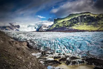
Vatnajökull Glacier
Vatnajökull Glacier, the crown jewel of the national park, is the largest glacier in Iceland and one of the most massive in Europe. It dominates the landscape and significantly influences the surrounding environment.
Vatnajökull Facts
Here are some key facts about Vatnajökull Glacier:
-
Size: 8,100 km² (3,100 sq miles)
-
Type of Glacier: Ice cap glacier
-
Elevation: Peaks reach up to 2,110 meters (6,920 feet) at Hvannadalshnjúkur, Iceland’s highest point.
-
Thickness: In some areas, the ice is up to 1,000 meters thick.
-
Age: Formed during the last ice age, around 2,500 years ago.
-
Biggest Glacier in Iceland: Vatnajökull accounts for about 8% of Iceland’s total land area.
Vatnajökull’s massive size and complex glacial systems make it one of Iceland’s most impressive natural features.
Glacier Geology and Surroundings
The Vatnajökull Glacier has a huge effect on the geology of this area. It shapes valleys and rivers, and even volcanic activity. The ice covers a large area of volcanic land, and as it melts, it feeds rivers and forms glacial lakes like Jökulsárlón.
Because of this glacier, even more beautiful landscapes have been formed, including deep valleys, geothermal areas, and lava fields that look like they belong in a different world.The sheer size of Vatnajökull means that it influences weather patterns and has a direct impact on the ecosystems around it. The surrounding natural hot springs, black sand deserts, and dramatic mountain ranges create a contrasting landscape from the glacier's ice surface.
Vatnajökull Volcanoes
Vatnajökull also covers a few active volcanoes, such as Grímsvötn, Bárðarbunga, and Öraefajökull, which are largely hidden beneath the glacier but at times erupt. Each of the volcanoes has its importance in designing the topographic appearance of the glacier and its surroundings. Many of the volcanoes are under the ice, while their contribution shapes the dynamic nature of the glacier. A list of the most prominent volcanoes within the Vatnajökull region is listed below.
Grímsvötn
Grímsvötn is situated in the southwest part of the Vatnajökull glacier and has repeatedly erupted. Its last big eruption occurred in 2011.Grímsvötn's volcanic activity is closely monitored due to its potential to cause significant glacial floods, known as jökulhlaups, when heat from eruptions melts large volumes of ice. The volcano sits within a caldera and has a subglacial lake.
Bárðarbunga
Bárðarbunga is another major volcano, located beneath the northwestern part of Vatnajökull Glacier. It’s one of the largest and most powerful volcanic systems in Iceland. The volcano’s massive caldera spans about 70 square kilometers (27 square miles). Bárðarbunga's most recent eruption, which lasted from 2014 to 2015, was one of the largest in Iceland in over 200 years and produced a significant lava field in the Holuhraun area.
Öræfajökull
Öræfajökull is a central volcano in the south of Vatnajökull, and home to Iceland's highest peak, Hvannadalshnúkur. Located beneath the ice cap, this stratovolcano is notorious for its violent eruptions. The most recent major eruption took place in 1727–1728. Öræfajökull, which is also a subglacial volcano, has caused destructive floods in the past due to the melting of glacial ice during eruptions.
Kverkfjöll
Kverkfjöll is a volcanic mountain range which sits on the northeastern edge of Vatnajökull. The mountain range is known for its geothermal activity which creates a hot spring area and ice caves on the glacier’s edge. The geothermal areas are most interesting because their scenery is unique and striking due to the combination of volcanic heat and ice. While Kverkfjöll is not as active as other volcanoes, such as Grímsvötn or Bárðarbunga, it still remains geologically significant.
Hamarinn (or Loki-Fögrufjöll)
The volcano Hamarinn, also known as Loki Fögrufjöll, lies to the west of Grímsvötn and beneath the glacier Vatnajökull, making it one of many subglacial volcanoes under Vatnajökull. The volcano is part of the Bárðarbunga fissure volcanic system, but is outside the caldera of Bárðarbunga itself. Similarly to volcanoes in its proximity, Hamarinn is known to produce jökulhlaups during eruption periods.Though it’s lesser known compared to some of its fellow volcanoes, it’s still an essential part of the area's volcanic activity.
Esjufjöll
The mountain range of Esjufjöll is made up of volcanoes and is located at the southeast corner of Vatnajökull. Even though the volcano is considered to be dormant, its geothermal activity is evident in the form of geothermal vents and subglacial calderas. Little is known about the eruptive history of Esjufjöll, but it is closely monitored for signs of future volcanic activity.
Þórðarhyrna
Þórðarhyrna is a volcano in the Vatnajökull Glacier, near Grímsvötn. Though not as prolific as some of the other volcanoes in the area, it has contributed nonetheless to forming much of the volcanic and geothermal landscape of Vatnajökull. The last known eruption of Þórðarhyrna occurred in 1903.
Askja (near Vatnajökull)
Unlike the other volcanoes, Askja is located near Vatnajökull instead of directly underneath it. Despite this, Askja forms part of the broader volcanic area, and is located just north of Vatnajökull Glacier. Askja is famous both for its vast caldera and for the crater lake, Víti. A volcanic desert surrounds Askja, in which geothermal activity is continuously present although its latest major eruption took place back in 1961.
These volcanoes, each unique in their activity and formation, make Vatnajökull Glacier an incredibly dynamic and geologically rich region. And ranking Vatnajökull among the most amazing natural sights in Iceland.
Where is Vatnajökull National Park?
Vatnajökull National Park is usually said to be located in southeast Iceland around Vatnajökull glacier. However, the park spans a collection of protected areas, stretching as far as Dettifoss and Ásbyrgi in the north of Iceland.
The 14,141 km2 (5,460 sq miles) area reaches from the volcanic canyon Eldgjá on the park’s west side to the east side of Vatnajökull, including Snæfell northeast of the glacier. The national park further extends to the protected area Jökulsárgljúfur in the north of Iceland down to the south coast as far as Diamond Beach.
How to Get to Vatnajökull National Park?
To visit Vatnajökull National Park, the most common starting points are Reykjavík and nearby towns like Höfn and Vík. Here are some route options:
-
From Reykjavík: Vatnajökull National Park is approximately 320 km (200 miles) from Reykjavík. The drive takes about 4-5 hours via Route 1 (the Ring Road).
-
From Höfn: A closer option, Höfn is just about 140 km (87 miles) from the main park entrance at Skaftafell, making it a convenient base for visiting the park.
-
From Vík: Located around 140 km (87 miles) west of Vatnajökull National Park, Vík is another excellent stopover for visitors traveling along the south coast.
Most attractions within the park are accessible by well-marked roads, though some require off-road vehicles or guided tours due to the rugged terrain.