Kolugljúfur Canyon is a raw and rugged slice of Icelandic nature, carved over millennia by the relentless force of the Víðidalsá River. It's well hidden in the northern region of the country and steeped in folklore - Kolugljúfur translates to Kola's canyon named by the troll said to live there.
The canyon itself stretches about a kilometer in length and plunges up to 50 meters deep, exposing layers of volcanic rock shaped by Iceland’s turbulent geological past. At its heart lies Kolufossar, a series of waterfalls where the river crashes into the depths below, sending mist into the air and adding to the site’s nature beauty. Despite its remote feel, Kolugljúfur is easily accessible, with a gravel road leading visitors straight to a parking area near the canyon's edge.
If you're looking to visit continue reading and find more out about what to expect when arriving there, how to include a hike in your visit and what to do in the area.
Kolugljúfur Facts & Figures
- Location: North Iceland, near Víðidalur Valley.
- Length: Approximately 1 kilometer.
- Depth: Up to 50 meters.
- Age: Formed over millennia by the erosive action of the Víðidalsá River.
- Folklore: Home to the female troll Kola.
Geography and Geology
Kolugljúfur Canyon lies in the interior of Víðidalur Valley in Iceland's north, cut over a span of many centuries by the unyielding force of the Víðidalsá River. The river, fed by rainfall and meltwater from glaciers, has eroded the rock over time to produce the steep cliffs and deep creases that define the canyon today. The result is a narrow gorge, about a kilometer in length and 30 meters in depth, that has been carved through about 3 million year old basalt lava layers and interlayers.

The bedrock of Kolugljúfur is made up of ancient basalt formations, a reminder of Iceland's fiery origin. The island is situated on the Mid-Atlantic Ridge, where the Eurasian and North American tectonic plates pull apart. Eruptions over millions of years have piled up layer after layer of lava rock, much of it worn smooth by wind, water, and ice erosion. In Kolugljúfur, the Víðidalsá River has cut through these layers, exposing the geologic story of the region in its canyon walls.
One of the most dramatic features of Kolugljúfur is Kolufossar, a series of waterfalls that tumble down into the gorge. These include Efrifoss (literally translating to 'the waterfall above'), Kolufoss and Neðri-Kolufoss (literally translating to 'the waterfall below'). The river bursts over rocky shelves, creating forceful cascades that spout mist into the air. The waterfalls become more turbulent in the springtime and after storms, more calm during arid summers. The force of the water continues to sculpt the gorge, deepening it over time and widening it.
Folklore
Not far from Kolugljúfur sits a farm called Kolugil in the far reaches of Víðidalur, east of the Víðidalur River. There lived a troll woman named Kola, and the farm was named after her. Below the farm is a dark and deep ravine, Kolugljúfur (translating to Kola's canyon), on the Víðidal River, and a waterfall in the gorge was said to be so high, Kolufoss (translating to Kola's waterfall) that no salmon could cross it, and therefore there was no more fishing in the river other than in the basin below the waterfall. The ravine, which was not very wide, was said to be impossible for most people to jump over it.

Now according to local legends, in the western gorge, somewhat lower than the edge of the gorge, is where high stone pillars stand out on the front of the ledge on both sides. Between these stone pillars is some depression in the rocks. Those ledges were said to be the edges of Kola's bedstead. These stories also mention that where the ledge is lowest, Kola would reach out of bed in the morning when she woke up and into the basin under the waterfall and took a salmon there and ate it on an empty stomach. Not far from Kolusæng (Kola's bedstead) is a large hole in the rock to the west, which is called Koluketill (Kola's kettle). She is said to have boiled the salmon she caught in the hole of the rock.
What to Expect When Visiting Kolugljúfur
Visitors can access Kolugljúfur Canyon via a gravel road leading from Route 1. The road is generally passable for most vehicles, but caution is advised, especially in adverse weather conditions. On this road, 715, you'll need to keep an eye out for a fork in the road and follow the path marked with a sign to Kolugljúfur. Otherwise you'll just loop back to the Ring Road.

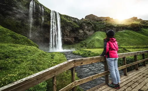
Upon arrival, there's a parking area close to the canyon. From the parking lot, a short walk leads to a vehicular bridge that offers views of the upper waterfalls and the canyon below. Observation platforms have been installed to provide safe vantage points for visitors on both sides of the canyon.

Facilities are minimal, with no restrooms or visitor centers on-site. Information signs provide details about the canyon's geology and folklore. Visitors typically spend about 30 minutes to an hour exploring the area, taking in the views and capturing photographs.
Hiking Kolugljúfur Canyon
While there isn't a formal hiking trail within the canyon, visitors can explore the area around the gorge. Paths along the canyon rim offer different perspectives of the waterfalls and the river below. It's essential to exercise caution, as the terrain can be uneven, and the edges may be unstable. Sturdy footwear is recommended.

There's little hiking around Kolugljúfur, however there's a dirt road path from the canyon on the east side leading back to Hrappsstaðarvegur road (also known as Kolugilsvegur), the same road visitors drive in on to reach the canyon. An example easy hike would be to take that path along the canyon for about 20 minutes and then turn around, following the same path back. That would include a hike of about 2.4 kilometers (1.57 miles) along the canyon. Those who venture on a hike are at their own responsibility and must at all times make sure to keep a safe distance from the canyon. It's essential to exercise caution, as the terrain can be uneven, and the canyon edges may be unstable. Sturdy footwear is also recommended.
Kolugljúfur Hiking Trail Stats
- Distance: 2.4 km (1.57 mi)
- Difficulty: Easy
- Elevation gain: 82 meters (272 ft)
- Time: 40 minutes
- Type: There and back
Where is Kolugljúfur Located?
Kolugljúfur Canyon is located in North Iceland, near the Víðidalur Valley. It's approximately halfway between Reykjavik and Akureyri, making it a convenient stop for travelers exploring the northern regions.
Kolugljúfur GPS Coordinates: 65°19'57.0"N 20°34'12.5"W
How to Get to Kolugljúfur
To reach Kolugljúfur Canyon from Reykjavik, take Route 1 (the Ring Road) northbound. You'll drive through Borgarnes, a town known for it's connection to the Sagas, and past Bifröst a small university town. From Reykjavík you drive about 200 km before reaching the turnoff for Road 715, known as Víðidalsvegur. Unlike the paved Ring Road you now drive on a gravel road towards the canyon. Víðidalsvegur is an offroad that loops straight back to the Ring Road, so you must look out for a fork in the road with a sign to Kolugljúfur. Follow this gravel road until you arrive at the canyon, located on your right hand side.
Kolugljúfur Canyon Parking
A gravel parking area is available near the canyon, free of charge. The parking lot is unpaved but generally accessible for most vehicles. From the parking area, it's a short walk to the bridge and observation platforms overlooking the canyon.
Parking GPS Coordinates: 65°19'58.0"N 20°34'10.3"W
Map of Nearby Attractions to Kolugljúfur
Kolugljúfur Canyon is a stunning natural wonder, but there’s plenty more to see nearby. North Iceland is full of unique geological formations, waterfalls, and historical sites that make for a great day of exploration. Consider adding these locations to your itinerary while in the area.
Bergárfoss Waterfall
Bergárfoss is a hidden gem located along the small river Bergsá, just a short drive from Kolugljúfur. This waterfall, though not as widely known as some of Iceland’s larger cascades, offers a peaceful setting away from the crowds. The waterfall is around 10 meters tall and flows down a rugged rock face, creating a beautiful contrast between the dark basalt and the clear rushing water.

Bergárfoss sits in a quiet rural area, surrounded by lush green fields in summer and snow-dusted landscapes in winter. The site is easily accessible by car, with a short walk leading to a good viewing spot. There are no major tourist facilities here, making it a great stop for those who enjoy nature in its raw, undisturbed state. Photographers will find plenty of angles to capture the falls, especially in the golden light of early morning or late evening.
Borgarvirki – The Natural Fortress
Borgarvirki is a fascinating geological and historical site, located about 35 km northwest of Kolugljúfur. This ancient volcanic plug, standing at an elevation of about 177 meters, has a commanding presence over the surrounding plains. Made of columnar basalt, Borgarvirki is a naturally strong defensive position, and historical records suggest that Vikings may have used it as a fortress.

The fortress-like structure features walls that rise steeply, enclosing a flat area within. Stonework has been added to reinforce the natural defenses, making it clear that this site was once of strategic importance. From the top, visitors get panoramic views of the surrounding region, including the vast, open landscapes of North Iceland.
A short but steep path leads to the summit, where an information plaque provides details about Borgarvirki’s history and geology. It’s an excellent stop for history buffs, geology enthusiasts, or anyone looking for breathtaking views over the Icelandic countryside.
Hvítserkur – The "Drinking Dragon" Rock Formation
Hvítserkur is one of North Iceland’s most iconic landmarks. This 15-meter-tall basalt sea stack rises dramatically from the waters of Húnaflói Bay, about an hour’s drive from Kolugljúfur. Shaped by centuries of wave erosion, the rock has taken on the appearance of a mythical creature—many say it looks like a dragon or a giant troll drinking from the sea.
According to Icelandic folklore, Hvítserkur was once a troll who lived in the Westfjords. The troll was caught in the sunlight while trying to destroy a nearby monastery and was turned to stone, forever frozen in place.

The best time to visit Hvítserkur is during low tide when you can walk closer to the base of the rock. The surrounding shoreline is also home to bird colonies, including fulmars and Arctic terns. The contrast between the dark basalt, the deep blue of the ocean, and the golden hue of the beach makes it a favorite location for photographers.
A viewing platform near the parking area offers great vantage points, and a path leads down to the beach for those who want a closer look. While there are no facilities on-site, the nearby town of Blönduós offers restaurants and rest stops.
Other Nearby Attractions Worth Visiting
- Vatnsnes Peninsula – A beautiful coastal region known for its rich wildlife, including one of Iceland’s largest seal colonies. There are several marked viewpoints where visitors can spot seals lounging on the rocky shores.
- Illugastaðir Farm – A historic farm with an eerie past, linked to one of Iceland’s most famous murder cases from the 19th century. The site is also a great place for bird and seal watching.
- Hvammstangi – A small fishing town with the Icelandic Seal Center, where visitors can learn about the region’s marine life and conservation efforts. The town also has a charming harbor area with local eateries.
These attractions, combined with the breathtaking views of Kolugljúfur, make the region an exciting stop for travelers looking to explore North Iceland’s natural and historical wonders.
Can You See the Northern Lights from Kolugljúfur?
Yes, Kolugljúfur's remote location makes it an excellent spot for viewing the Northern Lights during the aurora season, which runs from September to April. The absence of light pollution enhances the visibility of the auroras. However, sightings depend on solar activity and clear skies. It's advisable to check aurora forecasts and weather conditions before planning a visit for this purpose.

If you do choose Kolugljúfur for viewing the Northern Lights make sure the keep a good distance from the canyon. Your safest choice is to stay in the car park and note that there are no facilities at the location.
- Author Unknown. (n.d.). Íslenzkar þjóðsögur og goðafræði. Retrieved from https://skemman.is/bitstream/1946/3722/2/04032009092747134.pdf
- Náttúrufræðistofnun Íslands. (n.d.). Kolufossar. Retrieved from Kolufossar | Náttúrufræðistofnun Íslands